My most current blog entry:
A Petchaburi, Thailand 'Photo Ramble'
A 'photo ramble' blog entry in four parts: The Old Town of Petchaburi, The Buddhist Temples (Wats) of Petchaburi Town, Two Old Fishing Ports in Petchaburi Province, and Salt Pan Workers in Petchaburi Province.
PART 1: THE OLD TOWN
 Petchaburi is a provincial capital located between Bangkok and the beach towns of Cha Am and Hua Hin. It is a very small city that I pass by whenever I go to Hua Hin for a beach getaway from the pace of urban Bangkok . . . but I never stop to see what is there . . . until my old friend, John Stiles, and I decided to take a "photo ramble" there last week. [The 11th century Wat Mahathat Worawihan in the background.]
 Petchaburi is only two hours away on good divided highway from home . . . and seemingly in a different decade.
 We arrived and parked, as we planned to spend the day on foot. At first look, Petchaburi looks like a lot of old Thai market towns. An old, somewhat worn out downtown area with lots of 'street life' - civic culture. In Thai, Phetchaburi means "city of diamonds".
 There are some interesting old buildings with a lot of character . . .
 . . . and ample material for one of my favorite photographic subjects: old door portraits.
 A magnificent old door with its life story written all over it.
 Old Thai market towns have a special dilapidated charm I really enjoy.
 A corner coffee shop. We stopped here for iced coffee with milk. Very good.
 The Petchaburi clothing shops spill right out onto the sidewalks.
 Buddhist votive offerings shops near the main city center Wat (temple).
 These old wooden shop houses are slowly disappearing in Thailand's larger towns and cities.
 Our casual stroll brought us into an area of old alleys and a wet market.
 We were literally stopped in our tracks when we rounded a corner into this narrow alley . . . and found a street full of art. Fantastic!
 This was such a whimsical painting, made more so by the actual, real door knob that had been mounted in the wall!
 The wall art was wonderfully integrated into the structures of the alley.
 Dragon art . . .
 A drayman starting his rounds in front of a fish mural. Wonderful!
 There was a 'missing building' in the art alley . . . no problem: paint the revered former King of Thailand on the exposed end . . .
 There seemed to be a "pet" theme across much of the alley art work.
 Scrumptious and stylish . . .
 A wall of sweet kitties.
 None of this Petchaburi alley art was signed, but we guessed that these two lovely people were the artists.
 Refreshed with Art, we walked on through the alleys of old Petchaburi town.
 There were many very old shops in Peetchaburi . . . from a time before big box franchises and bar code stock control.
 I had the feeling that this woman has been sitting in this auto parts shop for a very, very long time.
 A city fabric shop . . . with cushions and plastic door mats.
 My friend John among the basketry taking candid street photos.
 Our wanderings brought us to the Petchaburi River, which bisects the city.
 We stopped here for a delicious lunch of noodle soup. Gotta love Thai street food!
 We left the old town and its interesting old alleys to explore the many Wats.
PART 2: THE BUDDHIST TEMPLES
 Wat Khoi on the outskirts of Petchaburi, near the hilltop Wat.
 Wat Khoi is a very special and architecturally unique Wat.
 Wat Khoi is in the shadow of the Petchaburi hilltop Phra Nakhon Khiri (Khao Wang).
 There is a very beautiful Kuan Yin statue in the garden of Wat Khoi.
 Wat Khoi had these amazing. worked metal bas reliefs of Thai people across a wall.
 The 500 year old Wat Sa-Bua was once a center of Buddhist evangelism in southern Thailand.
 Two kind Wat Sa-Bua monks opened up the ancient Wat for us to take photos. Thank you.
 This black Buddha statue is said to be even older than the Wat, +500 years old.
 An amazing tree on the Wat grounds . . . and a monkey!
 Wat Sa-Bua is built up against a wooded hill with many monkeys scampering all over!
 This ornery fellow let me know I was getting close enough.
 The rocky hillside behind Wat Sa-Bua haad fantastic old chedis.
 A beautiful and highly revered chedi.
 We enjoyed our time at Wat Sa-Bua, but walked on up the road to see more Wats nearby . . .
 The area near the hill attracted many monkeys . . . some ventured out into the nearby neighborhood on a monkey elevated highway!
 Yep, just a monkey hanging out on your roof.
 We drove up a small drive along the hillside hoping it would take us to the uppermost temples, but the road did not go all the way up. No problem, we found Wat Rattana Trai on the way.
 There was a marvelous old Wat at this hillside Buddhist compound.
 The beautiful arches and lighting made for perfect portraits. [Your humble photographer.]
 John and I took turns posing for portraits.
 I appreciate old doors, but this one was very special . . .
 Exquisitely inlaid door panels.
 There were many chedis up the hillside behind Wat Rattana Trai. So interesting.
 We walked back out through the beautiful arches to move on to the city center . . . and the big Wat there.
 Near the center of the old city we found the gate to the 11th century Wat Mahathat Worawihan.
 This ancient Wat had amazing old structures as well as new buildings, like this one. These are living, contemporary places of devotion, not abandoned museums.
 And we were not disappointed in the ancient temples still in perfect repair. So beautiful.
 Lovely artistry.
 A large Buddha image in one of the many small temple buildings within the grounds of Wat Mahathat Worawihan.
 The Wat temples were very crowed that day with devotees on Makha Bucha Day, a celebration of the ideal Buddhist community started by Buddha Gotama.
 This temple entry . . . . stunning artistry.
 Gorgeous Buddhist art.
 There were many monks around the Wat on this special day conducting blessings to the followers.
 This monk arrived at the temple and asked the 20 or so devotees to leave for a few minutes while he vacuumed.
 A 1000 year old window. Magnificent.
 An ancient founders' marker stone tablet.
 In our wanderings a round the Wat we came across this interesting building.
 Inside we found the monk meeting hall where the monks would gather every morning to take teachings from the Abbot.
PART 3: THE FISHING PORTS
 Rather than drive back to Bangkok, we spent the night just outside of Hua Hin. We woke up early to catch the sunrise along the road home. We stopped on this bridge over a canal for wonderful sunrise photos.
 Looking west along the same canal in the hot and humid misty Thai morning.
 The next morning heading back to Bangkok along the tiny local farm roads, we happened upon two fishing ports, the first of which was very small.
 I love these colorful Thai wooden fishing/squid boats.
 The first roadside fishing port was very small and seemingly very poor.
 These fishermen festoon their fishing boats' bows with colorful streamers for good luck.
 Where you have fishing boats and fish . . . you have cats.
 There was a primitive charm to this old, unnamed fishing port.
 The second port we 'discovered', Moo 2 (Bang Tabun, Ban Laem District, Petchaburi Province), was an industrial fishing port. Bigger boats, lots of warehouses and clean, orderly docks.
 A very busy port with boats coming and going all the time.
 A delightful nautical scene.
 Industrial squid boats with their outrigger bright light booms folded in. They catch squid by putting out very bright amber or green lights to lure the squid to the surface where the deck crew scoops them up with net scoops on long poles.
 There were only a few of these small boats here.
 I could have stood on this bridge watching the fishing boats come and go all day. But we needed to move on.
 Before leaving the Moo 2 fishing port we explored a nearby Wat with amazing carvings on the roof ends.
PART 4: SALT PAN WORKERS
 Back on the small coastal road we drove into a salt pan area with many white egrets.
 We saw many of these old salt warehouses bursting at the seams out in the salt pans as we drove along . . . and wondered if there would be salt harvesting.
 It wasn't long before we found the salt workers toiling in the heat to remove the salt, two baskets-full at a time.
 Damp salt cones, raked by a previous crew, await portage.
 Hard work: scooping damp salt into your baskets and lugging it out to the road . . . but still a friendly spirit.
 The 'salt boss' keeping track of basket loads . . . many Thais wear these masks when working in the sun . . . they do not want their skin to become dark.
 There was a steady line of salt porters delivering their loads from the pans.
 No reason to not be colorful and stylish . . . .
 Reflecting on our experience, we had a wonder-full 36 hours in Petchaburi city and province. Did I really just say that?
 Dr. Jeff Harper
Rural Thai Temple Loi Kratong Celebration
 A young couple setting their kratong to float into Klong Ha (canal 5). Loi Kratong is a wonderful occasion in Thailand . . . everyone participates.
 Driving home from an evening of testing at my local drag strip, I noticed many cars parked near the rural canalside Buddhist temple. So I stopped to take a look.
 I parked and walked across a narrow bridge toward the lights in the distance.
 I entered the temple grounds through a 'side entrance' . . . lots of motorcycles parked.
 Although it was a festival, a trampoline was the only amusement here for the kids in this rural location.
 Once inside, I joined the crowd of rural Thai folks enjoying the evening out.
 And what the people had come for was to stroll about the temple grounds eating various Thai treats, watching presentations and dancing on a stage, meet with the Buddhist monks for blessings, make a donation to the temple, to purchase or make their own kratong, and to launch their kratong into the klong (canal).
 There were rows and rows of food stalls set up for the evening.
 As always in Thailand, were was every imaginable delicious thing to eat on sale . . . readymade dinner packs . . . .
 What would a festival be without deep fried frog?
 The deep-fried bug snack stall was doing a brisk business.
 The fried bug stall had two kinds of grasshoppers: these 'type A' grasshoppers, and . . .
 . . . and these 'type B' grasshoppers. Take your pick.
 If you were looking to munch on something a little more crunchy, there were the deep-fried june bugs on offer in green and black.
 If crispy bugs weren't to your liking, there was also the chewy option: deep-fried and highly spiced grubs. Mmmmmmm!
 For this festival, the food stalls had been erected in and among the temple buildings and large Buddha statuary.
 At the base of this Buddha statue many local ladies were crafting kratongs for purchase to benefit the temple.
 An onsite workshop of kratong production.
 I purchased one of these kratongs made with a banana stalk base. "A krathong is traditionally a small floating container fashioned of leaves which is made to hold a small portion of goods like a traditional Thai dish (such as hor mok) or dessert. The traditional krathong used for floating at the festival are made from a slice of a banana tree trunk or a spider lilly plant. Modern krathongs are more often made of bread or Styrofoam. A bread krathong will disintegrate after a few days and can be eaten by fish. Banana stalk krathongs are also biodegradable, but Styrofoam krathongs are increasingly banned, as they pollute rivers and oceans." (**) There were NO kratongs for sale at this temple with Styrofoam bases . . . I was very happy to see that.
 In addition to having kratongs for sale, there was a "Best Kratong" contest! Here are a few of the entrants:
 This entry in the "Best Kratong Contest" was very beautiful.
 My favorite to win the contest: the COVID-19-themed kratong. Yes, let's send the virus down the river along with our best wishes for a better life in the future.
 The families would eventually wait their turn to enter a temple structure to pay respect to the Buddha.
 Buddhism is a living "religion" in Thailand. Families carry out ancient rituals still today.
 Small donations are placed on these bushes like leaves. Sweet.
 Just wandering around the wat to enjoy the Buddha imagery.
 The 'Wat festival' is not only a celebration of Loi Krathong and a fund raising event for the temple, it is also a community event. A stage is set up for local rural folk to share cultural and artistic expression, like this troupe of elderly traditional Thai dancers.
 The traditional Thai dance group being publicly acknowledged and praised.
  Community leaders and event organizers acknowledged by the area political leader.
 I took my new kratong (float) toward the canal to launch it and was met with throngs of people now entering the Wat for the festival and launching their own kratongs. Notice everybody eating some delicious Thai snack or other.
 I arrived at the canal as the crowds poured in across the bridge.
 A nice family photo just before launching their individual krathongs.
 I pressed myself into this human mass to launch my own kratong, express my hopes for the coming year, and send respect to the Buddha.
 Such a wonderful sight: a whole community collectively floating away the bad from last year and the hopes for the coming year.
 And one giant krathong for the entire community and Wat.
 The whole scene brightly lit up in fantastic colorful neon arrays.
 Reflect light on Klong 5. Magic.
 Extraordinary reflection!
 When I left I crossed back over the bridge and saw this amazing scene!
 Looking across the canal to the other side, I noticed just as many people there crowding to float their kratongs.
 Looking back under the bridge to the Wat side of the canal . . . many, many people out joining in an ancient Thai cultural tradition.
 My last look back at the the rural Loi Krathong festival . . . way out in a dark Thai farmland night.
USA Road Trip: Carlsbad Caverns National Park, NM
 On my early October drive from Sante Fe, New Mexico to the Formula One race in Austin, Texas, I stopped to visit the famous Carlsbad Caverns National Park in southern New Mexico.
 During my childhood my family moved throughout the western states of the USA. I remembering seeing signs along Route 66 imploring passers-by to visit Carlsbad Caverns. I finally made it 50 years later!!!
 I was not disappointed! I paid the entry fee and took the elevator to the depths of earth.

The cave is well-known for its many calcite formations such as this column and array of stalactites. (**)
 Although I did not bring a tripod for these long exposure, low light photos, I was able to brace my camera on the guardrailings. Low light photography is my favorite. [These are all ISO bracketed 3-shot captures from a Fuji X-T2 camera, post-processed in the Luminar HDR software. I was happy with the shadow detail and not having the brightly lit areas 'burned out.]
 Giant columns of dripping calcite.
 A 'waterfall' of stone. Amazing.
 The spiky ceilings were captivating.
 I would not want to be down here in an earthquake! First, you would be iimpaled by these needles and then crushed by the millions of tons of rock above you.
 Some of my photos were dictated by the location of the guardrail. But it didn't matter: there was something interesting in every direction.
 It was very dark inside the caverns (possibly to prevent the growth of mold).
 Creepy, creepy formations everywhere.
 A cascade of flowing rock . . . it seemed to be in motion . . .
 The many 'off limits' side passages invited my curiosity . . .
 The guardrails in this photo gives you an idea of how huge some of the large caverns were.
 Nicely lit coves. I am glad they used the same light tone throughout (The stalactite caves in Gibraltar succumbed to a revolving color wheel light effect . . . horrible!)
 And deeper and deeper I went into the caverns . . . The climate of the caverns is described as "humid tropical" . . . I felt like I was back in Bangkok! Nice!
 And deeper and deeper I went into the cavern. I visited in early October, so there were very few tourists on the day I visited. Normally, 450,000 people visit the cavern every year.
 There was a crystal clear underground stream running through one of the big rooms.
 The cavern path is several miles long. At the other end were 2000 feet of stairs to reach the surface. I made the decision to turn back after about a mile so that I could take the elevator back up.
 I had a wonderful two hours exploring the Carlsbad caverns. I highly recommend it . . . even if you have to wait 50 years.
USA Road Trip: Zion National Park
 Zion National Park is situated in southern Utah.
 Remarkably photogenic landscapes around Zion . . . this may be one of the best photos I have ever taken . . .
 The geology and topography of Zion National Park is truly fantastic.
 We stopped often along the winding road to marvel at the rock formations.
 Massive stone mountains.
 A lone pine with a geological marvel as a backdrop.
 I cannot imagine what geological forces created this formation. AMAZING!
 Around every curve in the road was another magnificent geological scene. WOW!
 This road!
 I love this scenery: pine trees nestled within desert rock formations.
 Inexplicable shape and pattern.
 Ancient trees among the desert mountain scenery: perfect.
 Dry desert stone, a lone lizard . . .
 A stack of giant stone pucks . . .
 Yes, actual cactus in the desert . . . who knew?
 A mix of many different geological formations . . . all overlapping.
 Along the road that goes up and out of the park.
 Just another grand and gorgeous landscape.
 Zion must be a rock climber's dream!
 A desert stream falling through a rocky canyon. So beautiful.
 Three rocky peaks along the road . . .
 Morning wild flowers.
 The most popular part of the park are the deep, narrow orange canyons. To access this part of the canyon you have to board a shuttle bus. It's a good idea . . . it keeps the pollution down, and there would have to be huge parking lots in the narrow canyon.
 The route to the park visitors center on the bus goes into an ever-deepening canyon.
 Into the deep canyon . . .
 More photogenic scenes than I had time to capture . . .
 Sheer stone cliffs towering above the stream and greenery below.
 Beautiful light on these carved cliffs . . .
 Giant blocks of stone all around.
 The trees contrasted against the backdrop of black and orange cliff faces was a magical sight.
 Blackened cliff, greenery.
 The Virgin River flows at the bottom of Zion Park canyon.
 Many tourists visit Zion National Park every year. The path up into the famous narrow gorges crosses this bridge.
 It was a hot day in June, so some of the tourists were cooling off in the Virgin River.
 Looking up the Virgin River from the bridge. The path follows the river on the left bank up into the steep valley.
 The path up into the park is well-worn by millions of tourists every year.
 The path follows the Virgin River, offering wonderful views.
 Up we went toward the "waterfall".
 Hot tourists stopping to cool off to the steep uphill path.
 Massive cliffs overhead at the "waterfall" - if you look closely you can see a trickle of water falling over the cliff.
 The path under the "waterfall."
 The "Waterfall." The display at the visitors center said it was a massive waterfall in late spring and when sudden summer flash floods made the streams rage. OK.
 These squirrels and a few lizards were the only wildlife we saw.
 And onward we hiked into the deep cliff-sided Virgin River valley.
 The sight of these rapidly forming clouds convinced us not to go any further. We headed back down the trail to the visitors center.
 The walk back down was just as beautiful.
 Such a pleasant walk in such grand Nature.
 We grabbed a bite to eat at the visitors center and sat on the big lawn under a tall tree.
 We purchased a bag full of Zion park themed tourist curious at the visitors center and headed for the tourist shuttle bus.
 The shuttle system works very well in the park.
 The views from the shuttle bus were fantastic too.
 Back to the camper and a drive out of the park . . . with a few stops for more scenic grandeur.
 Back at our hotel. There was a small tourist town where we found a "cowboy steak house" - expensive, but delicious.
USA Road Trip: Bryce Canyon National Park, Utah
 Bryce Canyon National Park is one of the great natural wonders of the world. The area around Bryce Canyon was originally designated as a national monument by President Warren G. Harding in 1923 and was redesignated as a national park by the U.S. Congress in 1928.
-----------------------------------------------------------------
 Out in the beautiful south Utah desert landscape. Red rocks, wild geology, and hoodoos. . . . .
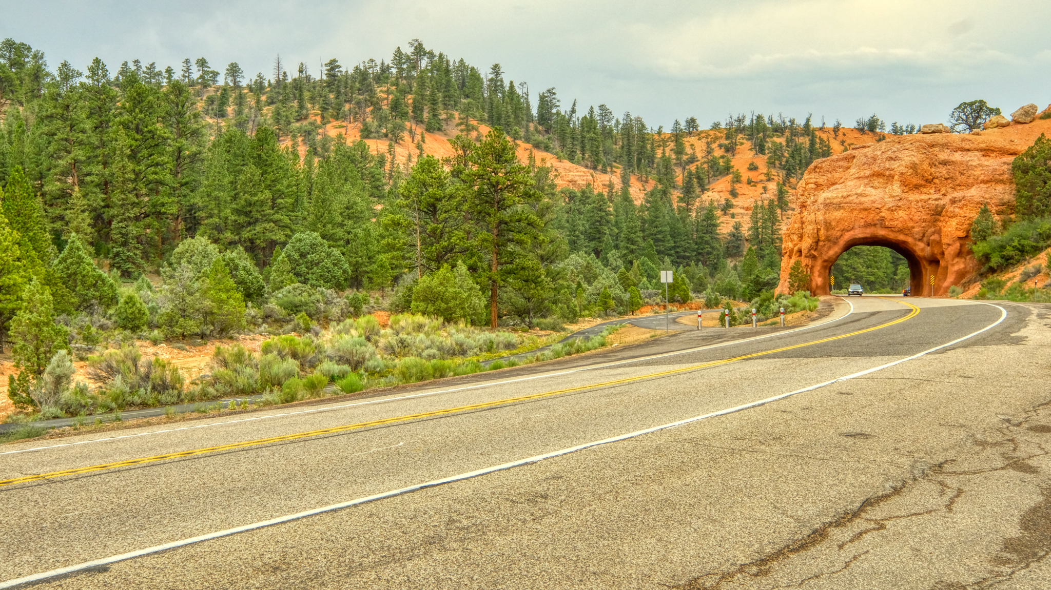 It was a very interesting drive up in altitude to Bryce Canyon National Park.
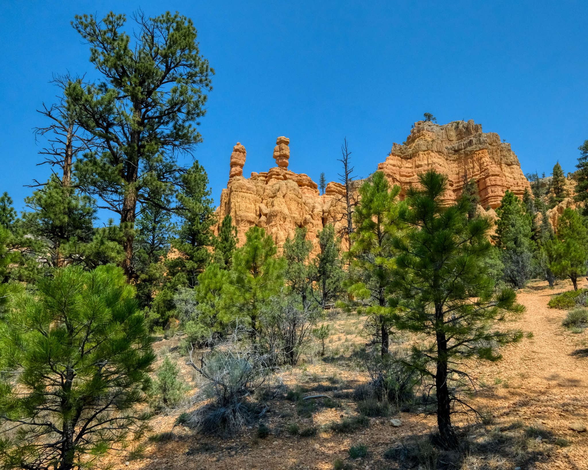 Roadside hoodoos.
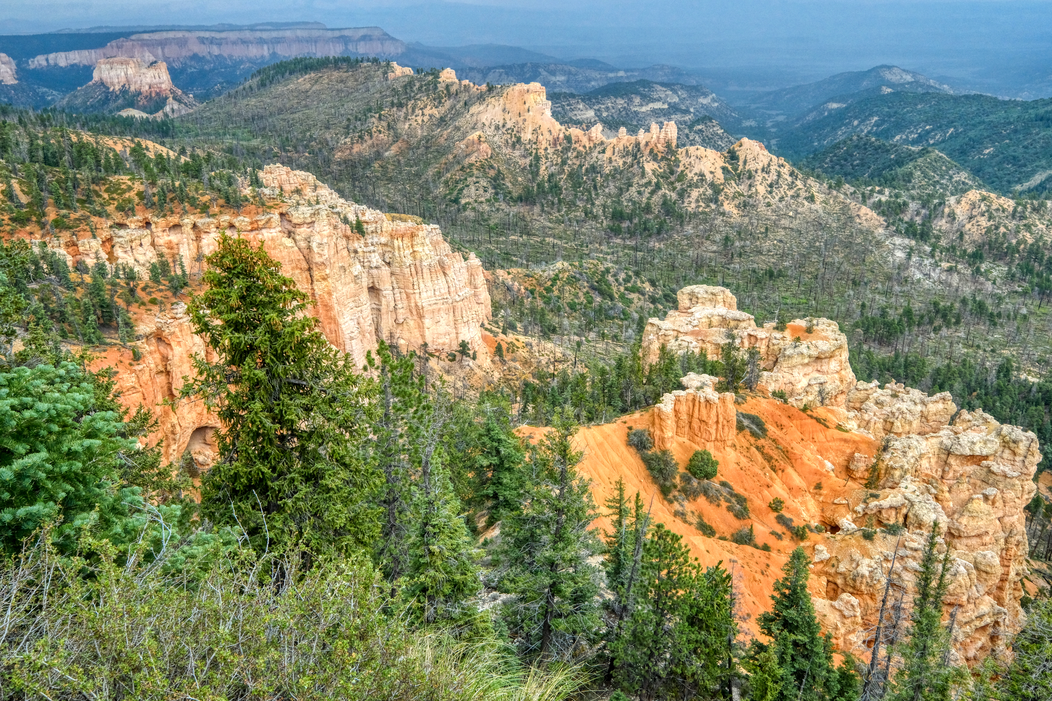 Such scenic views on the road up to the park!
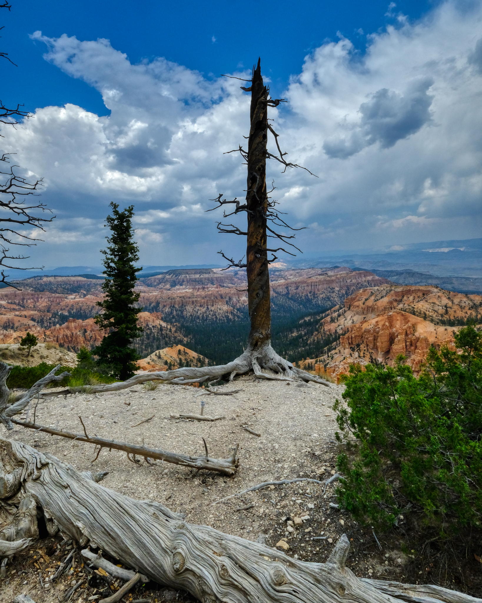
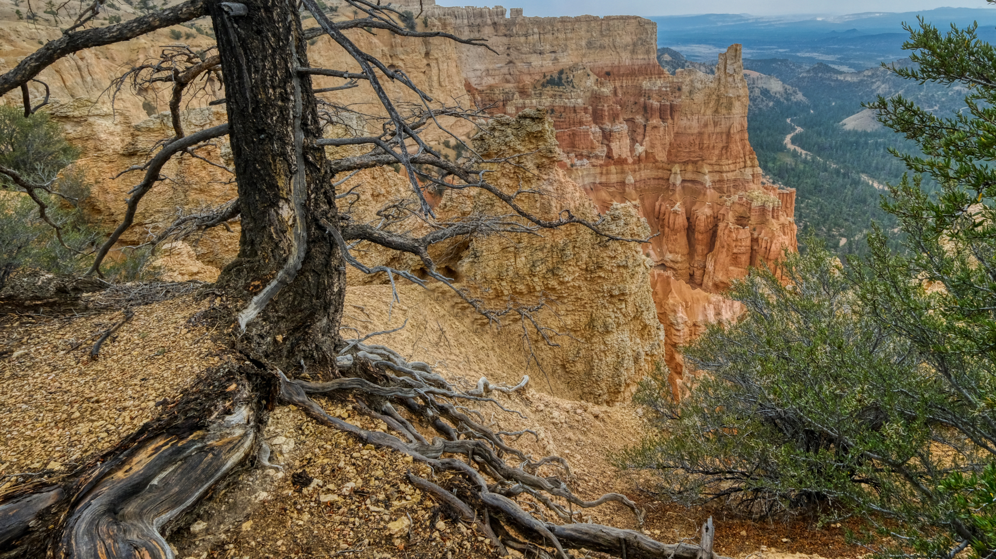 An old snag, perhaps a lightning strike, along the edge of the canyon.
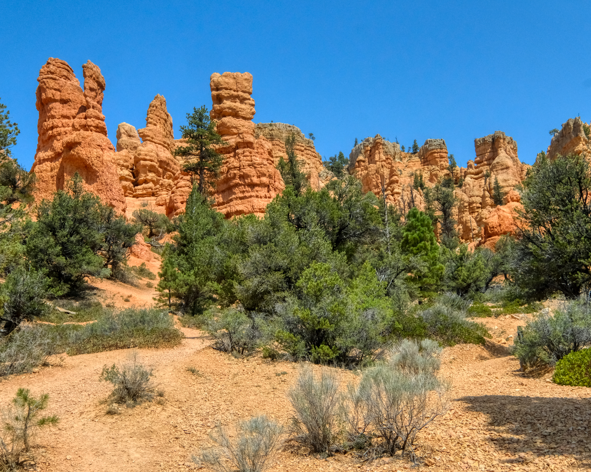
 Weathered red rock spires . . .
 Strangely carved cliffs with inviting caves . . .
 The closer we got to the canyon, the more interesting things we saw.
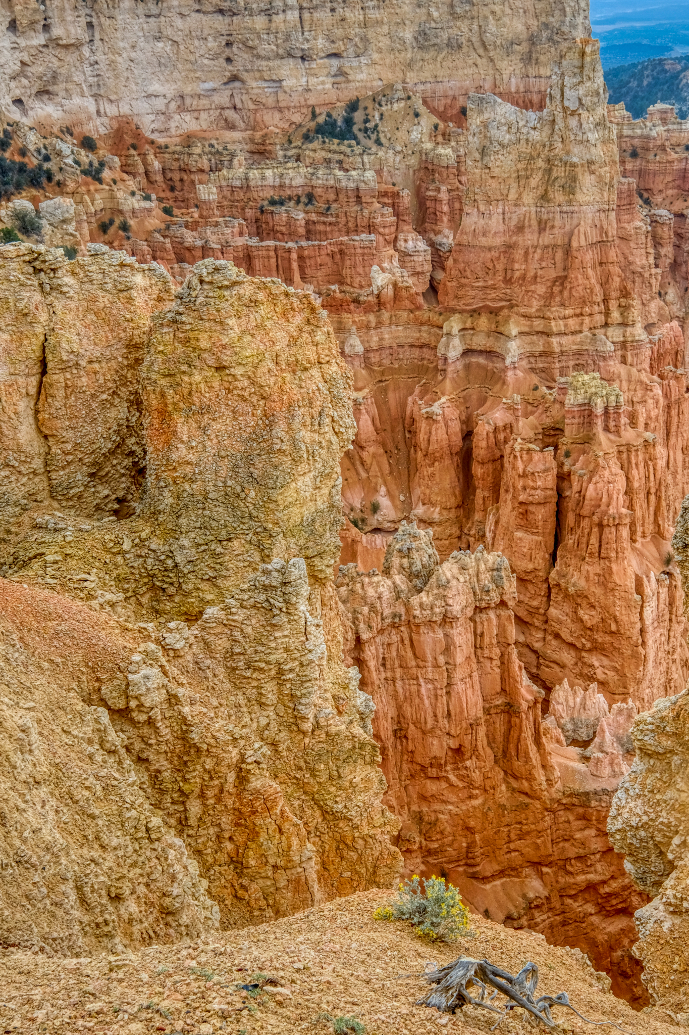 Amazing geology.
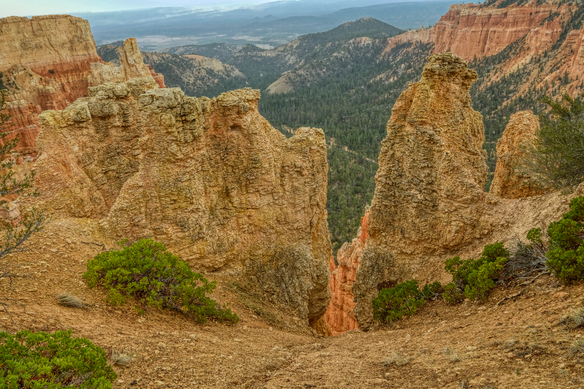
 The trail along the rim of Bryce Canyon offered many viewing points . . .
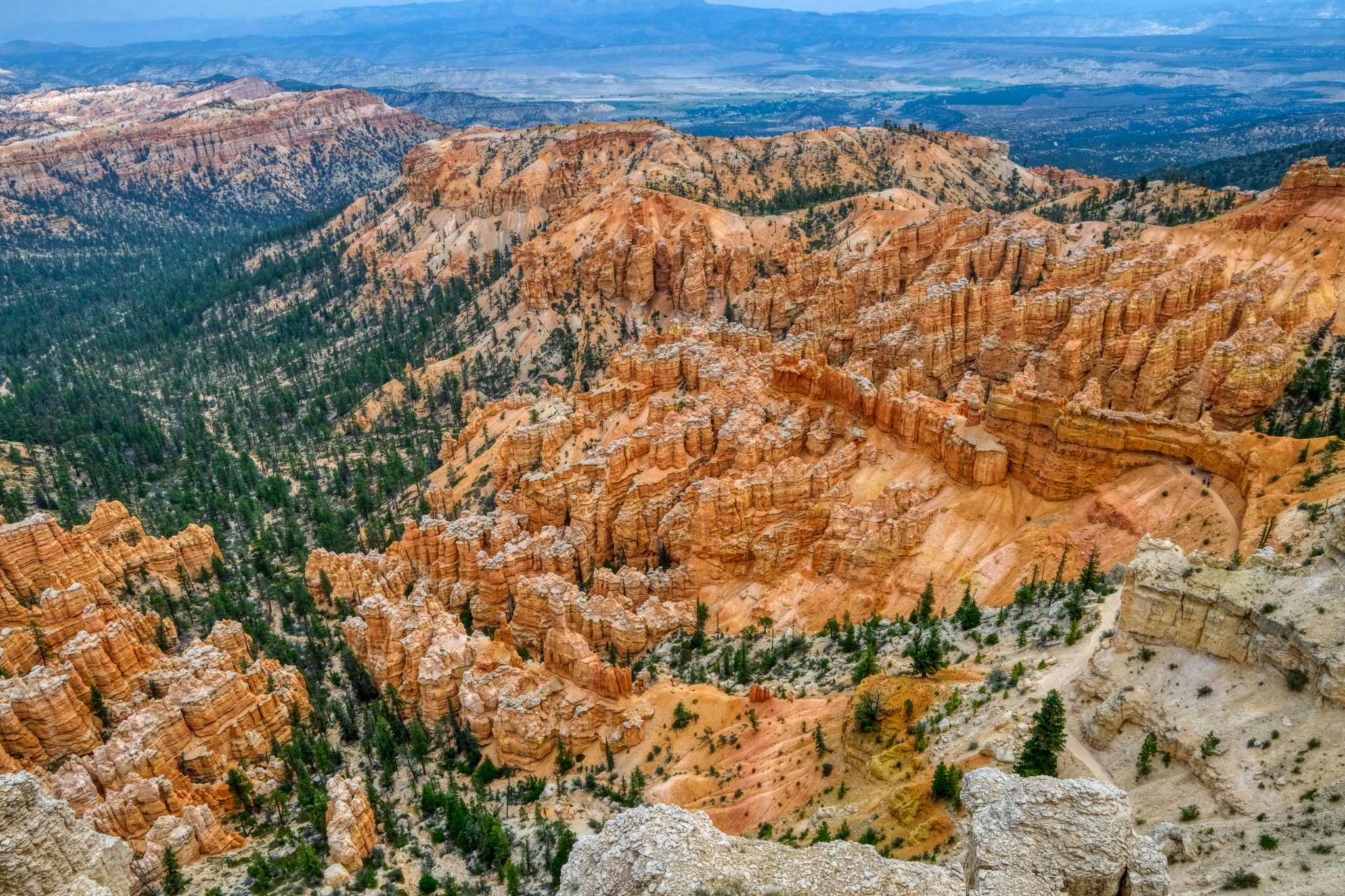 . . . and grand views!
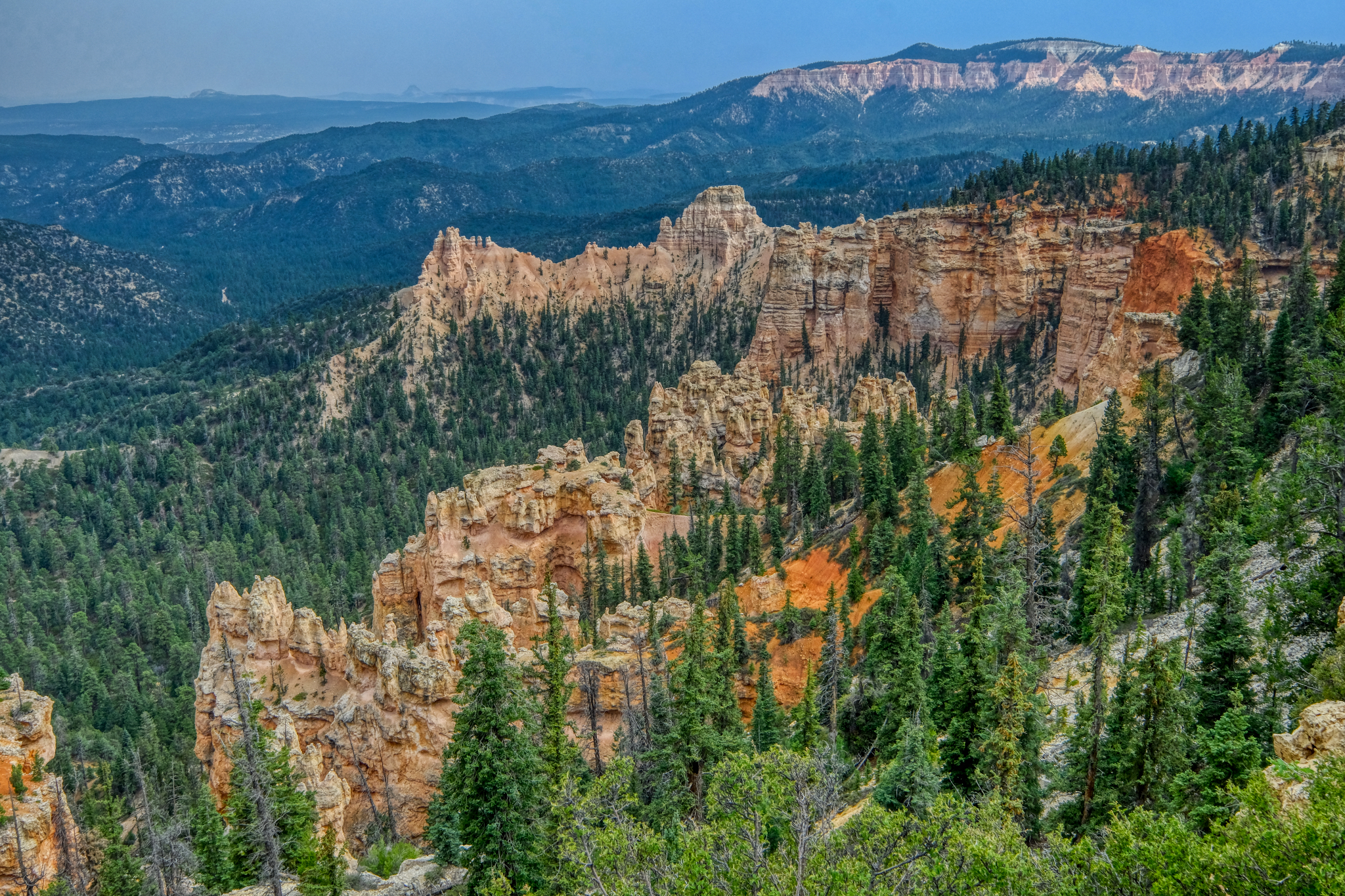
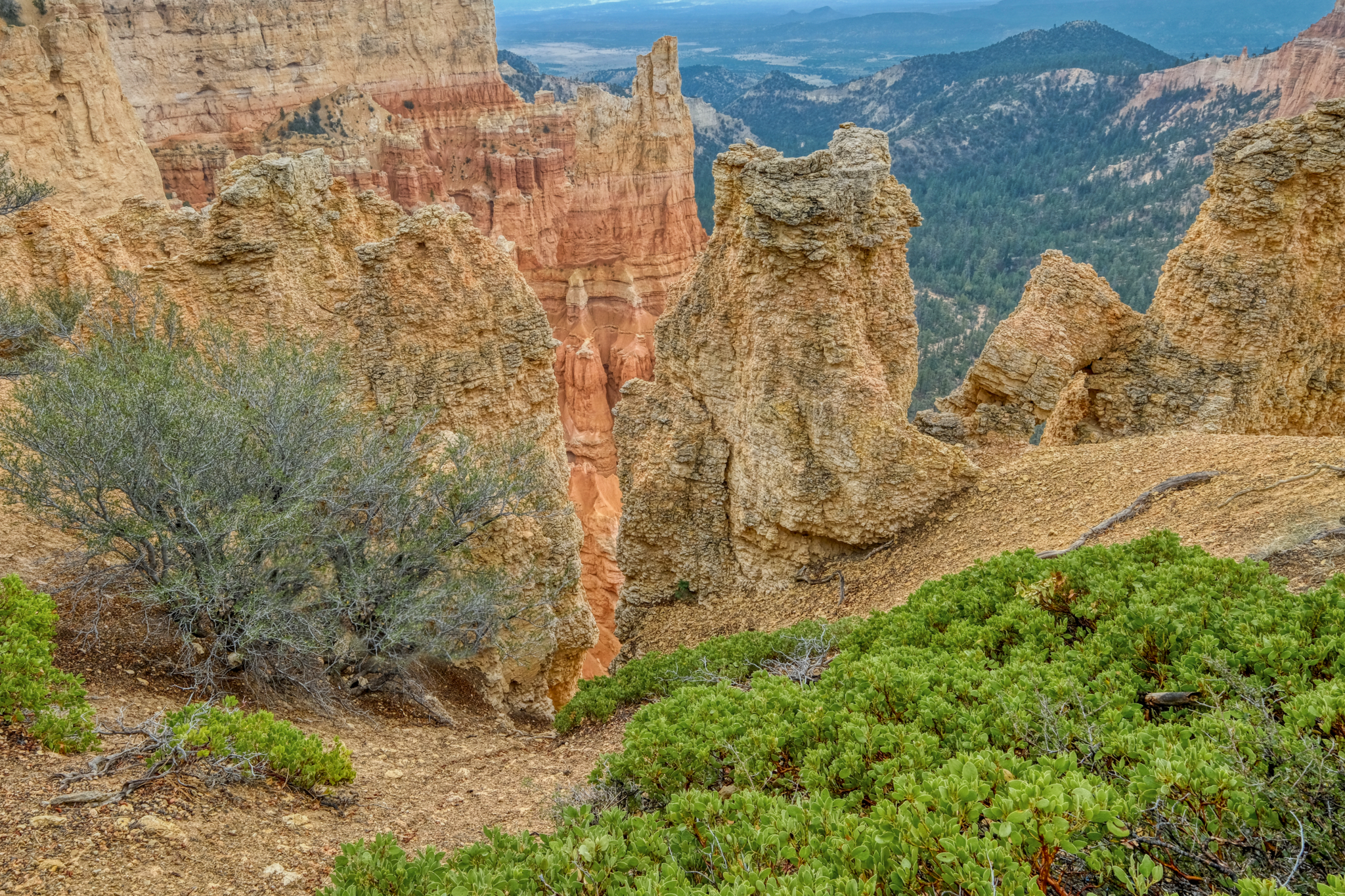
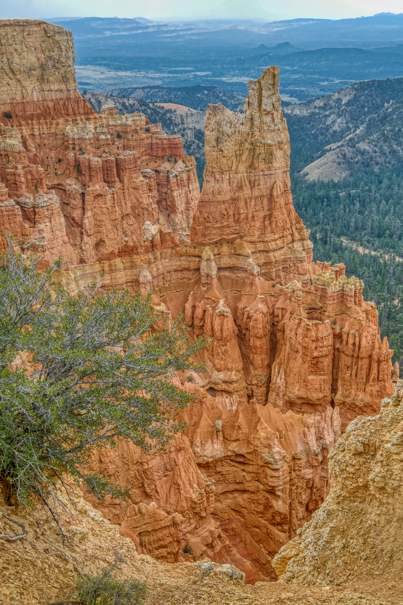
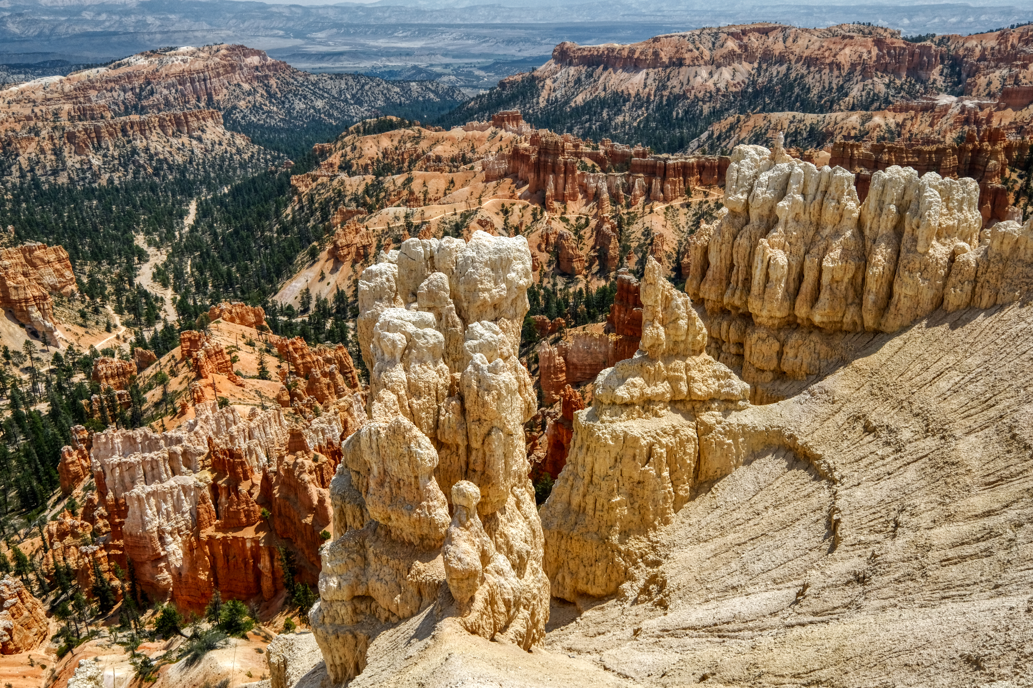
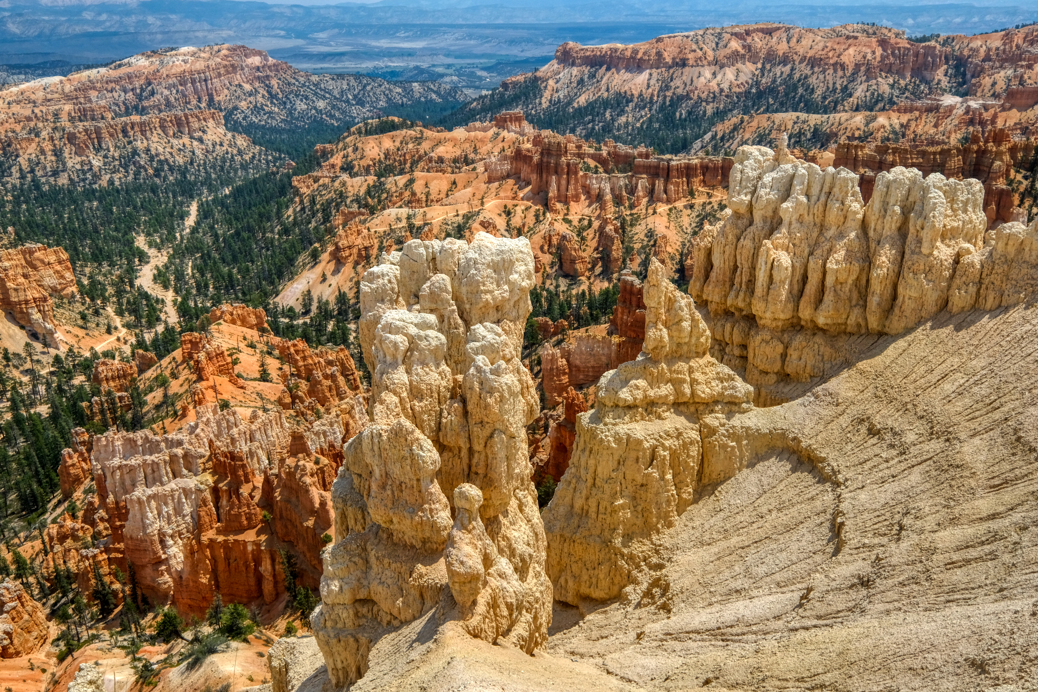 Amazing rock formations!
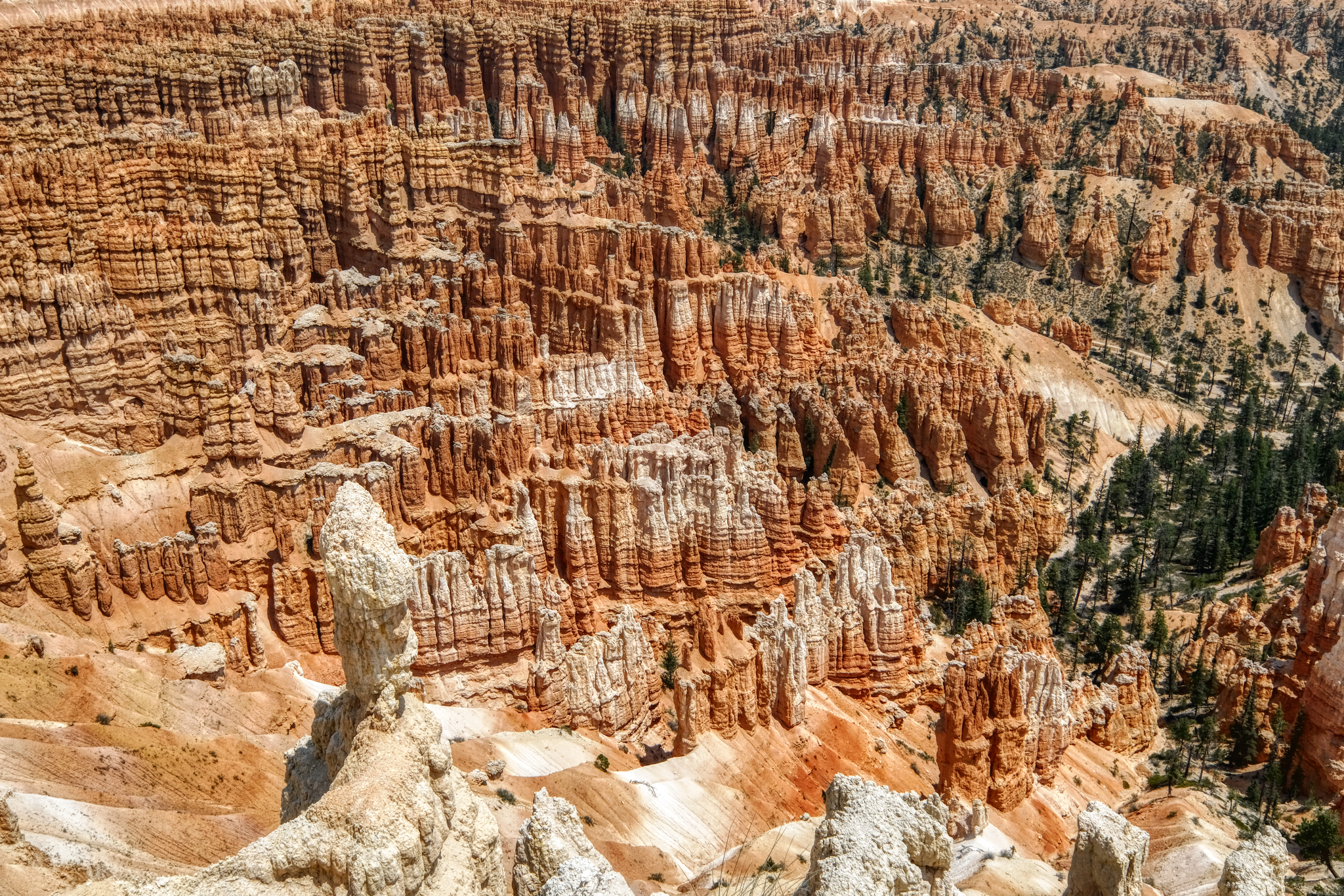
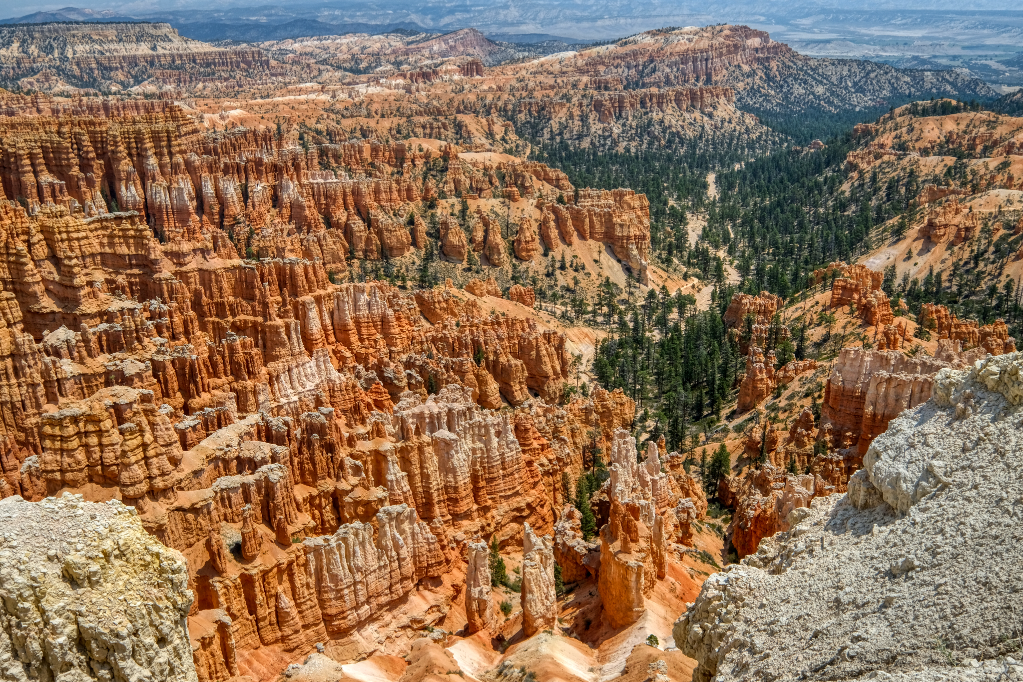 Thousands of wondrous stone spires into the distance.
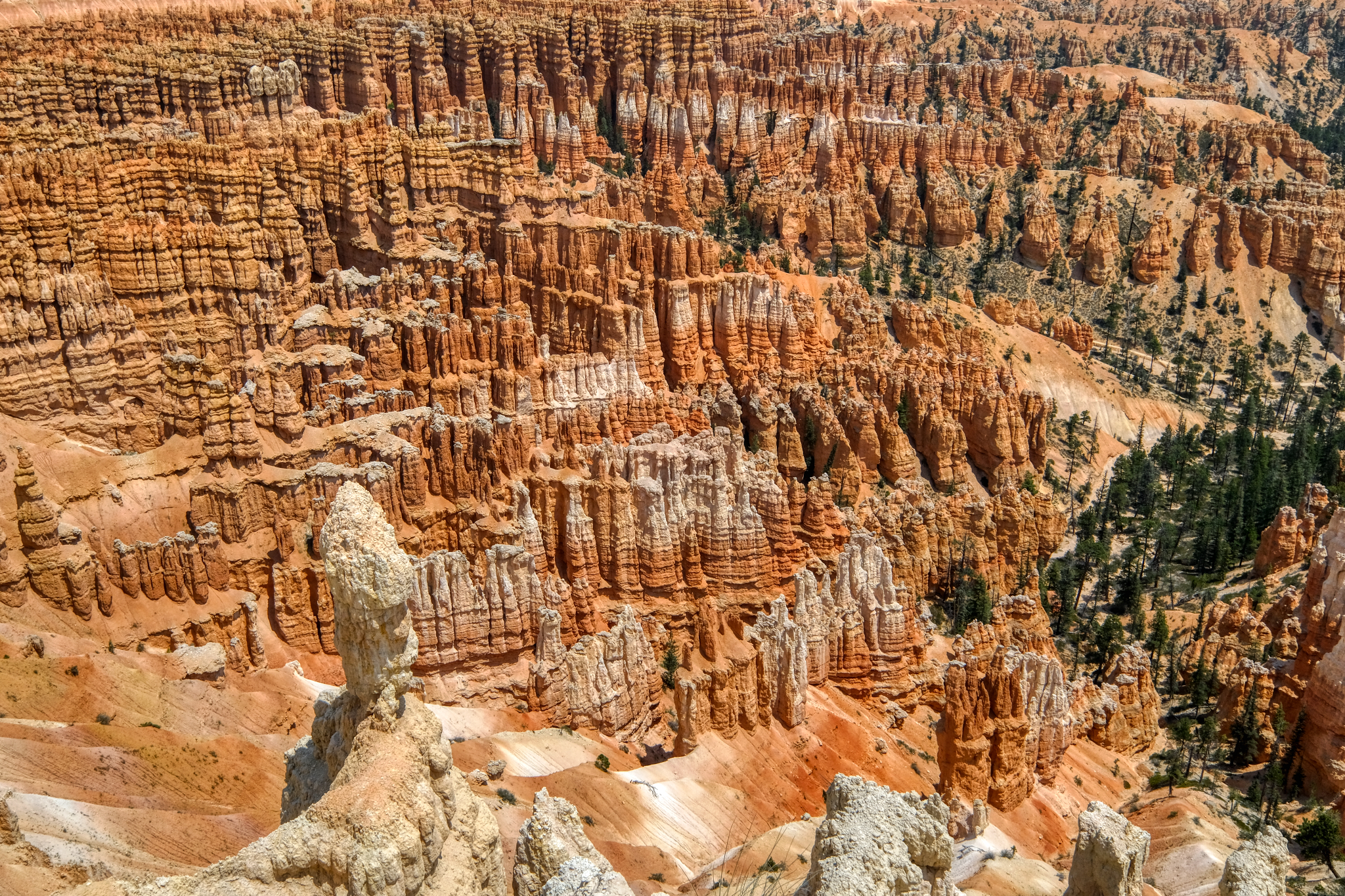 Just incredible! NATURE!
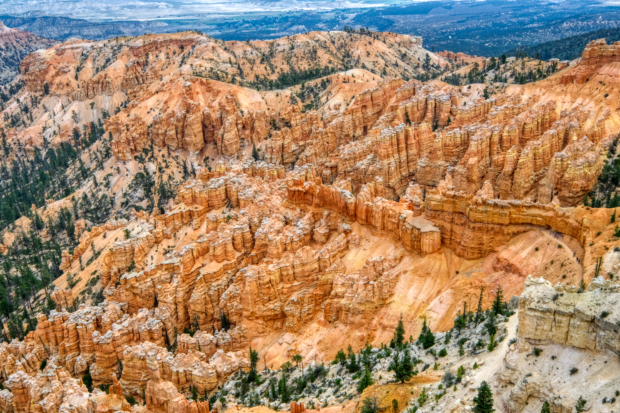 If you look closely, you can see that there are many walking trails through the spires . . sadly, we did not have time to walk any of them. Next time.
 Another burnt lightning snag along the rim trail.

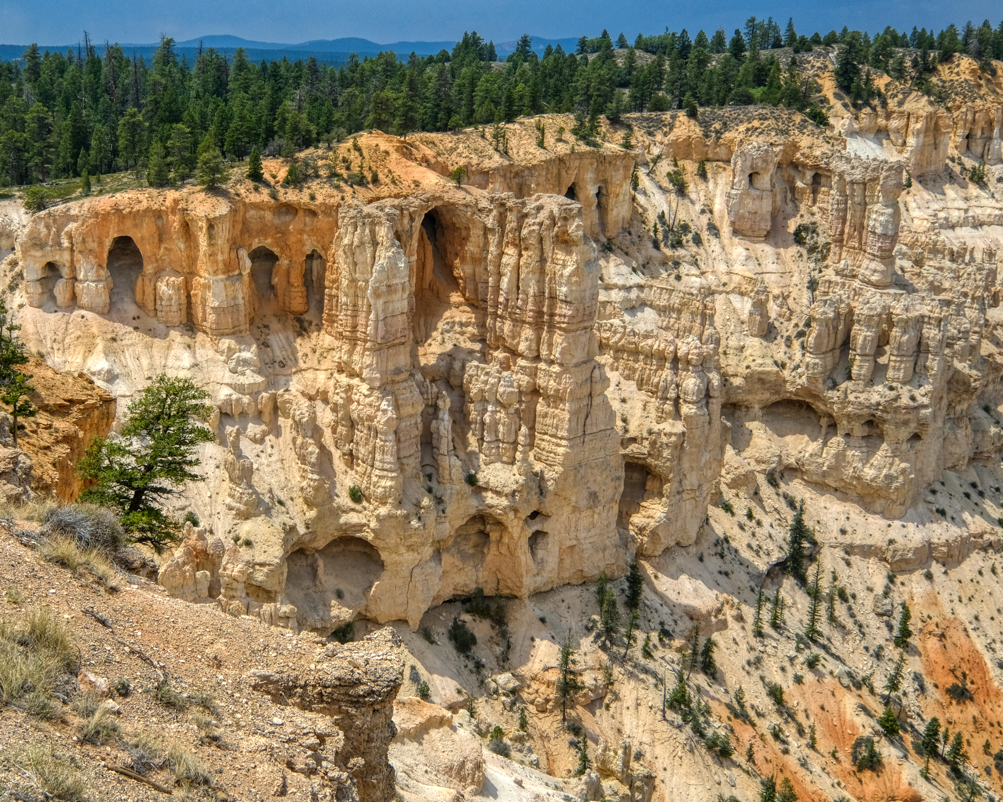
A phenomenal sight!
 Standing out on a promontory above the canyon.
 Different color rock formations . . .
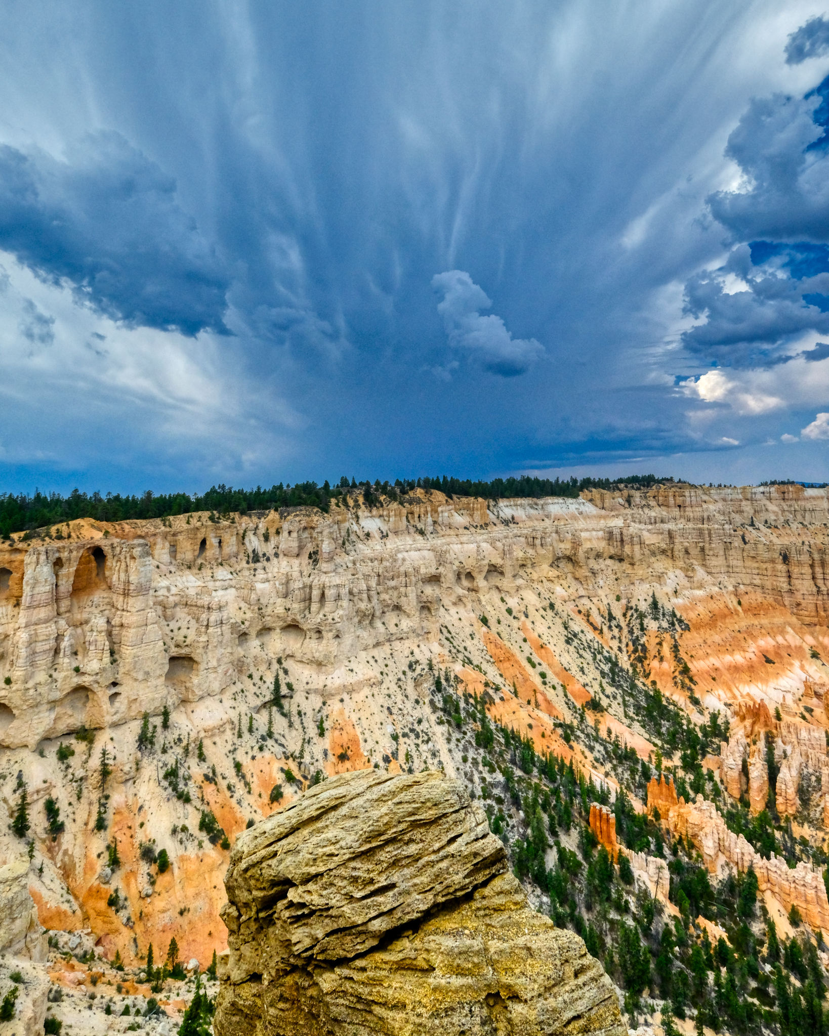 An angry storm approached very fast. At this altitude there are always summer thunderstorms.
 A light ran began as we hurried back to the camper.
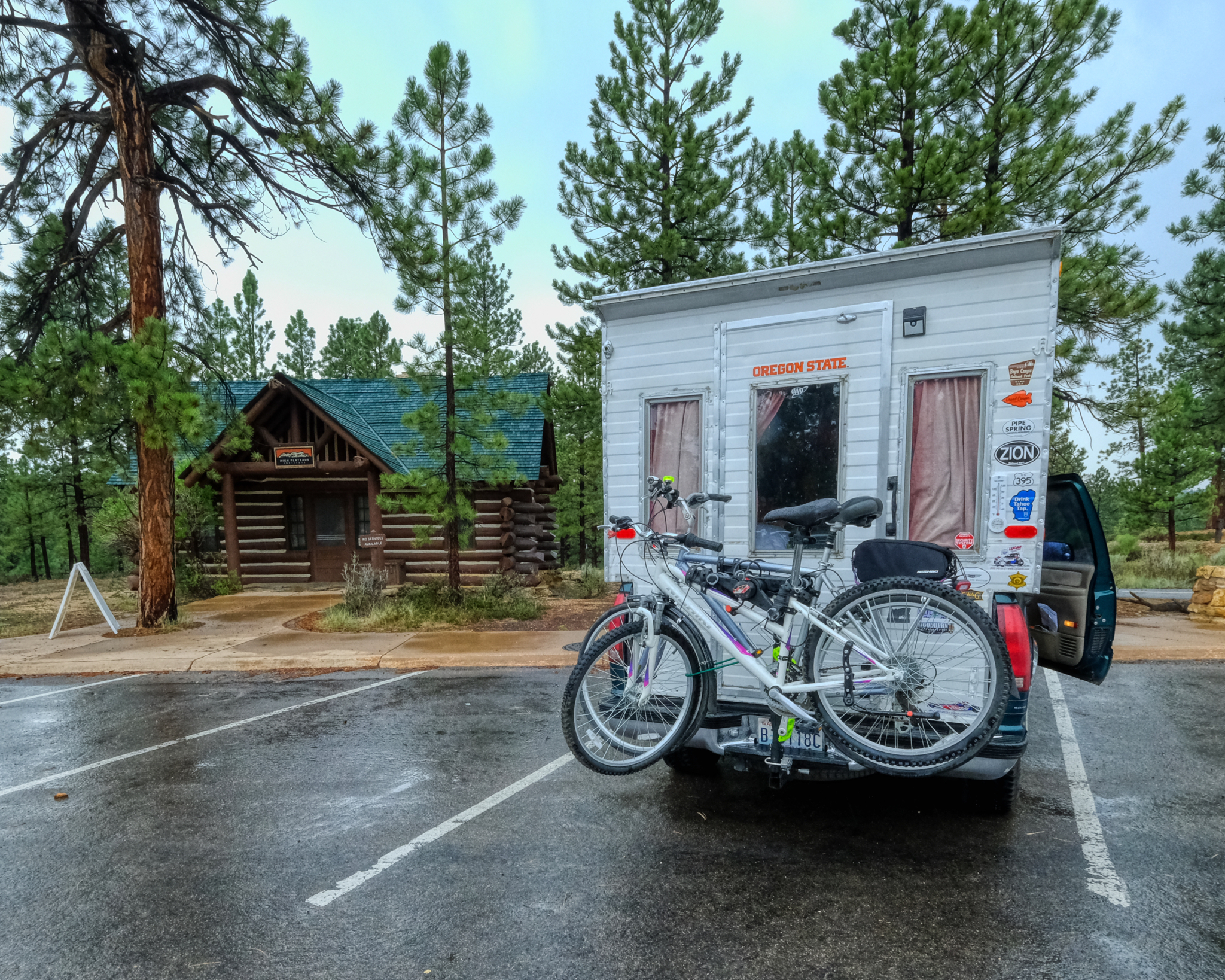 We made it back to the camper as the skies opened.
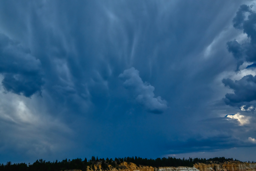 The Storm.